London to create a digital map of underground infrastructure
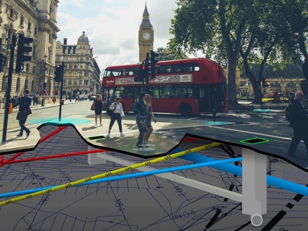
London officials are planning to create a digital map with the city's underground network of pipes and cables.
The purpose of the attempt is to increase safety measures during underground works and reduce the maintenance costs of the network. UK's Geospatial Commission will be responsible to create the underground map which will include gas and water pipes as well as electricity and telecommunication cables. According to officials, the total cost of accidents in underground infrastructure can reach up to $1.5 million annually.
“When workers strike pipes and cables it risks lives, costs money, causes havoc for residents and road-users. Our investment in this groundbreaking data sharing model is just one way that the government is working smarter so that we really make a difference to people’s everyday lives,” Oliver Dowden, Cabinet Office minister, stated.
Greater London Authority (GLA) in cooperation with local authorities and infrastructure providers will lead the underground mapping in the city of London. In the North East, the attempt is led by Ordnance Survey, collaborating with Northumbrian Water, Northern Gas Networks, Northern Powergrid, and Openreach. “The creation of an underground map of utility assets has long been an ambition of Ordnance Survey, and over the last year we have been working closely with Northumbrian Water, and a consortia of utility companies and local authorities in the north east of England, to explore how accurate geospatial data can improve underground infrastructure maintenance and inform new build development projects. The investment being made by the geospatial commission will ultimately enable the utility industry to more efficiently access, use and share data describing otherwise hidden infrastructure, thereby reducing operational costs, minimizing disruption and accelerating completion of site works,” the managing director of Ordnance Survey Great Britain, David Henderson, stated.
Until now, efforts to produce underground maps of infrastructure have been conducted by some organizations but there is a lack of a universal, detailed map. When the project is completed, workers will be able to see pipes and cables using their smart phones or laptops before they begin an underground work.
Sources: Fibre-systems.com, Computerweekly.com, Utilityweek.co.uk
Sources: Fibre-systems.com, Computerweekly.com, Utilityweek.co.uk
Want to read more like this story?

New technique to carry freight through underground tunnels
Dec, 02, 2019 | NewsA new company suggests a method to carry freight through underground tunnels. Magway, a start-up...

More than 80% of underground water in China is heavily polluted
Apr, 12, 2017 | NewsIndustrial pollution and farming has rendered it unsuitable for human use Industrial pollution an...
Robots to fix underground pipes
Feb, 11, 2019 | NewsAn innovative project suggests that robots can be employed to repair damage in underground pipes. A...

The Price of Progress: Why UK Infrastructure Costs Need Reform
Oct, 10, 2024 | NewsThe rising costs of infrastructure projects in the UK have been a significant concern for decades,...
Heat produced by an underground line to warm houses in London
Sep, 05, 2019 | NewsA brand-new innovative plan suggests utilizing heat produced by an underground line to warm houses d...
New study finds signs of underground climate change and influence on civil infrastructure
Jul, 19, 2023 | NewsA new study by Alessandro F. Rotta Loria of Northwestern University, titled “The silent impact of u...
How to tackle underground stations inundation
Oct, 01, 2021 | NewsAs weather phenomena tend to become more intense, a crucial question is how to protect the undergro...

Abandoned tunnels can be used as underground farms
Nov, 19, 2018 | NewsResearchers from Nottingham University suggest that underground facilities, that are not currently u...

Smarter Cities Start with Better Maps: Geospatial Tech and Sustainability
May, 01, 2025 | NewsAs urban populations grow and the climate crisis intensifies, civil engineers and urban planners ar...
Trending

Vertical gardens in Mexico City to combat pollution

Saudi Park Closed After 360 Big Pendulum Ride Crashes to Ground, 23 injured

Characteristics of Load Bearing Masonry Construction

Taipei 101’s impressive tuned mass damper

Dutch greenhouses have revolutionized modern farming

Federal court rules Biden’s offshore drilling ban unlawful


